It’s June 1 and the official start of the “hurricane season” in the Atlantic. Right on cue, we may have a tropical depression and/or tropical storm impacting central and southern Florida. More on this threat for the (not so) sunshine state in a little bit.
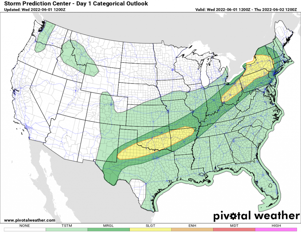
Showers and thunderstorms, some of which could be severe, will be sprawled out over the nation from New England and Upstate NY, into the Ohio and Mississippi Valleys, and into the southern Plains, as far south as Texas. Heavy rains, frequent lightning and damaging wind gusts are possible with these storms. This front will sink south and eventually stall out late this week across the Southeast and the lower Mississippi Valley, as the upper air wind flow over the US goes almost perfectly “zonal” or west to east. No big ridges. No big troughs. It’s been awhile since we’ve seen this! It means over the northern US over the next several days, at or below normal temps (which for June should be comfortable) and at or above average temps across the southern US (which for June means hot and humid).
Turning our attention to the Tropics, near Cancun is where the remnants of what was Hurricane Agatha from the eastern Pacific a few days ago, are. As this moves into the NW Caribbean and the Gulf of Mexico, there is a high chance this remnant low will redevelop into a separate and new tropical system. If it does so, its name would be ALEX. And that is the expectation from the National Hurricane Center over the next few days. Regardless of how it develops, expect lots of clouds and heavy rains for central and southern Florida starting Friday and lasting through the weekend. If you picked this time to go to Florida for sun and the beach, I’m sorry. You’ll be pissed. There won’t be any sun. Just a lot of rain, storms and gusty winds.
The European model is insisting this Tropical Depression and/or Tropical Storm will landfall on the SW coast of Florida somewhere near Ft Myers on Saturday morning, then push across the Everglades and Lake Okeechobee leaving the east coast of Florida by Sunday. The ranges from best case to worst case scenario are getting closer. If you are south of I-4, expect Friday through Sunday to be cloudy, windy with a ton of rain and thunderstorms. Flooding is increasing in likelihood. If this thing does gather strength, there could be wind damage in SW Florida, but ALEX does not look to become a hurricane at this time, nor would this be a destructive storm, or one where mass evacuations would happen. But with the tropics, NEVER ASSUME. Just keep your eyes on the situation every six hours and prepare accordingly.
Free step-by-step guide lorem ipsum dolor sit amet, consectetur adipiscing elit, sed do eiusmod tempor incididunt ut labore et dolore magna aliqua.
© 2022 Rich Lupia, Lupia & Associates, LLC. All Rights Reserved.
SITE DEVELOPED BY BROCKETT CREATIVE GROUP, INC