
Apologies for being away the last several days. I’ve been on the road, and will be coming to you from Upstate NY for the next week. Not far from Matt Clark world headquarters 🙂
Here in the Northeast it’s a cool late June morning. With the exception of a few clouds zipping through northern NY and northern Vermont, the rest of the Northeast, Great Lakes and Ohio Valley looks like a 10/10 today. Tons of bright sunshine. Temps in the 70s, low humidity and about 5-10 degrees of the normals for this time of year. In late June, unless you want to “fry” or “bake” at the beach, most folks probably won’t mind. It looks to stay this way the next few days. End of this week the heat and some humidity will return.
Across the Southeast, the front that delivered the refreshing air to the Northeast does what fronts do in late June… STALL. The front is hung up over North Carolina, the Upstate of South Carolina, northern Georgia and into Alabama and Mississippi. Here there will be scattered showers and thunderstorms both today and tomorrow. Given the recent heat waves and relatively dry conditions, some rain would actually be a good thing. Another good thing is the actual temperatures… about 5-10 degrees below normal here as well with lots of high 70s and 80s across the board. Very few folks east of the Mississippi will reach the 90s today.
Severe weather threats are only SLIGHT and confined to Wisconsin and Montana, small areas of concern. Wind damage the biggest threat from thunderstorms.
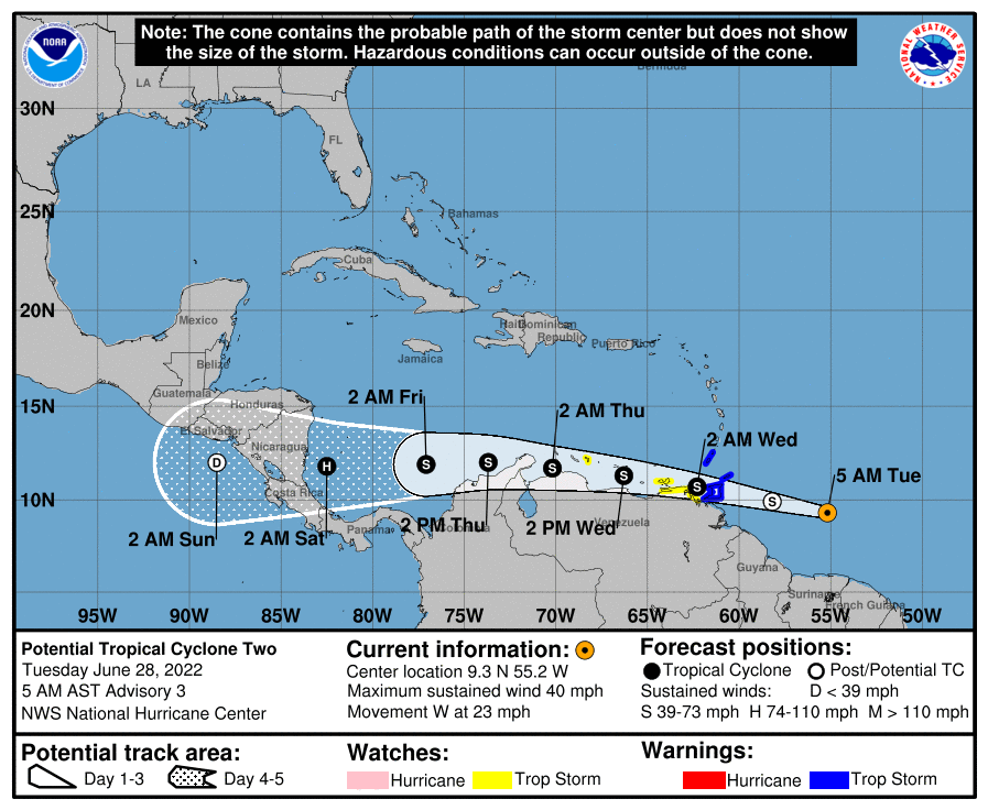
We end today’s report with a BONNIE. Potential Tropical Cyclone 2, as of this writing, is expected to become Tropical Storm Bonnie later today or tomorrow. This has been a strong tropical wave for days, unusually far south across the Atlantic (south of 10 degrees N latitude), and will be positioned across the southern Caribbean. The northern coasts of Venezuela and Colombia will take the brunt of anything Bonnie has to offer. It heads for landfall in Nicaragua at the end of this week, then scoots into the Pacific. Who knows what happens to it from there, but if it does make it that far, it will be the second storm to go Atlantic/Pacific or Pacific/Atlantic before July 4th. That is a rare feat. Gotta keep our eyes on the tropics and I will.
Enjoy your beautiful late June weather across a good portion of the nation! Talk to you tomorrow.
Rich
Born and raised in Utica, NY. I have been in Greenville, SC since 2020 and love it here! I've been married over 20 years to my wife Amy and we have four kids (Zack, Ariella, Lillian and Aiden)
I am blessed beyond measure!


